Archives
Enter a word or phrase to perform a general search across all records in the Archives catalog. You can also browse records in the catalog without performing a search.
Search Tips
- Searches are not case sensitive.
- Searching for multiple words connects them with OR by default. Matching records can contain any of the words.
- Connect multiple words with AND if you only want to see records containing both words.
- Use quotation marks to search for a phrase.
- Place an asterisk (*) at the end of a word as a wildcard.
400 results found. Records searched: 400
-
-
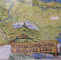
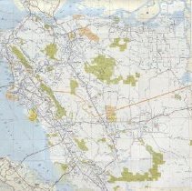
MAP.E-061 - CONTRA COSTA CANAL REGIONAL TRAIL
Summer 1991, vol. 5, no. 2 of "On Tap", published by CCWD
Record Type: Archive
-
-
-
-
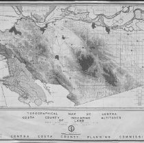
MAP.E-064-1 - Topographical map of Contra Costa County indicating altitudes of land
Basic data for the Master Plan of Contra Costa County. Undated. Similar data map for Master Plan dated 1945 (E-064-2)
Record Type: Archive
-
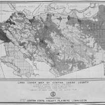
MAP.E-064-2 - LAND COVER MAP OF CONTRA COSTA COUNTY
A graphic inventory of general land cover inclusive of natural cover as well as that resultant from human habitation. compiled as basic data for the Master Plan. Approved Jan 25, 1945
Record Type: Archive
-
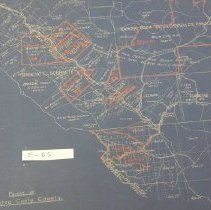
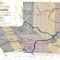
MAP.E-065 - Portion of Contra Costa County. Map undated (publication date 1910)
Rancho el sobrante, Rancho Acalanes, Rancho Boca De La Canada De Pinole
Record Type: Archive
-
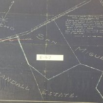
MAP.E-066 - Map: the partition of the Boss Ranch
Boss Ranch: Surveyed according to the direction of G.P. Loucks, A. Dorman, T. Griffin. By E.C. Brown, August 1881
Record Type: Archive
-
-
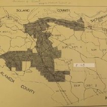
MAP.E-068 - Boundaries of present Mosquito Abatement DISTRICT #1
Mosquito Abatement District outlined on map
Record Type: Archive
-
-
![[MAP OF CONTRA COSTA COUNTY]](https://s3.amazonaws.com/pastperfectonline/images/museum_1332/003/thumbs/mape070.jpg)
-
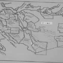
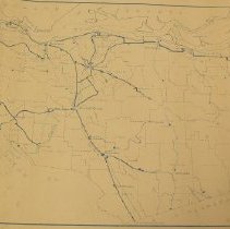
MAP.E-071 - MEXICAN RANCHOS OF ALAMEDA AND CONTRA COSTA COUNTIES Boundaries as established by the United States Surveyor General [1850's]
2 copies
Record Type: Archive
![MEXICAN RANCHOS OF ALAMEDA AND CONTRA COSTA COUNTIES Boundaries as established by the United States Surveyor General [1850's]](https://s3.amazonaws.com/pastperfectonline/images/museum_1332/003/thumbs/mape071.jpg)
-
-
-
-
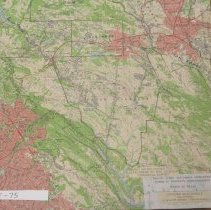
MAP.E-075 - Land grants in central Contra Costa County
Map is Concord Quadrangle 15 Minute Series. Land grant boundaries have been drawn on map.
Record Type: Archive
-
Map.0586 - Moraga area general plan, planning area 5, Contra Costa County, California
Shows land use: residential, service and employment, recreation and open space. Shows community facilities and traffic circulation, major county roads and existing, adopted, and proposed freeways. Adopted by the Contra Costa County Planning Commission 29 July 1969. Adopted by the Contra Costa County Board of Supervisors 2 December 1969.
Record Type: Archive

-
Map.0587-Map.0595 - Road map of the State of California
Shows existing US and California State highways, proposed state highways, cities and towns, distances between cities. Shows roads and towns in the entire state of California. There are also insets on the recto ad verso of major cities and metropolitan areas, including San Francisco and vicinity and San Francisco Bay region. Has a numerical list of state highways. Holdings: 1948 (Map.0587), 1949 (Map.0588), 1951 (Map.0589), 1954 (Map.0590...
Record Type: Archive