Archive Record
Images
Metadata
Object ID |
MAP.E-075 |
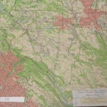
Title |
Land grants in central Contra Costa County |
Description |
Map is Concord Quadrangle 15 Minute Series. Land grant boundaries have been drawn on map. |
Collection Name |
Maps Collection |
Year |
c1960 |
Map Area / Region |
Central Contra Costa County |
Publisher of Map |
GEOLOGICAL SURVEY (U.S.) |
Scale of Map |
[1:62,500] |