Archives
Enter a word or phrase to perform a general search across all records in the Archives catalog. You can also browse records in the catalog without performing a search.
Search Tips
- Searches are not case sensitive.
- Searching for multiple words connects them with OR by default. Matching records can contain any of the words.
- Connect multiple words with AND if you only want to see records containing both words.
- Use quotation marks to search for a phrase.
- Place an asterisk (*) at the end of a word as a wildcard.
400 results found. Records searched: 400
-
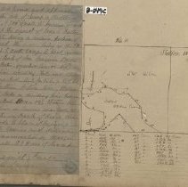
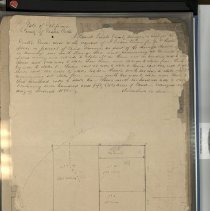
MAP.B-049A - Untitled map - parcel on bank of San Joaquin River
Original hand drawn map. Sale of swamp or overflowed land belonging to the State; surveyed at request of William Logat (sp?). On a bank of the San Joaquin River. Left hand edge of description is damaged and not legible.
Record Type: Archive
-
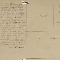
MAP.B-049B - Untitled map - parcel on bank of San Joaquin River
Original hand drawn map. Sale of swamp or overflowed land belonging to the State; surveyed at request of William Ugate (sp?). On a bank of the San Joaquin River.
Record Type: Archive
-
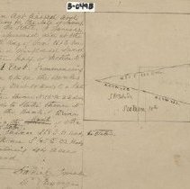
MAP.B-049C - Untitled map - parcel on bank of San Joaquin River
Original hand drawn map. Sale of swamp or overflowed land belonging to the State; surveyed at request of Jane E. Fuller. On a bank of the San Joaquin River.
Record Type: Archive
-
MAP.B-050 - Untitled map - partial survey on Moraga Ranch
Hand drawn-ink. March 1856. Request of Elam Brown for George C. Bates for survey of parcel of land known as part of the Moraga Ranch. Bancroft Library preserved the map for CCC History Society.
Record Type: Archive
-
MAP.CC-001 - Virginia Avenue, Richmond
Plat of Assessment District for opening... Virginia Avenue, Richmond. One map - Court case "CoRichmond vs ATSF RR 1915."
Record Type: Archive

-
MAP.CC-002 - Florida Avenue, Richmond
Plat of assessment district for the opening of Florida Avenue in Richmond. One map - Court Case "CoRichmond vs ATSF RR 1915"
Record Type: Archive
-
MAP.CC-003 - Third Street, Richmond
Assessment district for the opening of Third Street in Richmond. Resolution - Court Case "CoRichmond vs. Charles Horan 1914" One map.
Record Type: Archive
-
MAP.CC-004 - Tenth Street, Richmond.
Area required and assessment district for widening of Tenth Street, Richmond. One long folded map. "CoRichmond v. Ludewig, C.R. et al., 1915."
Record Type: Archive
-
MAP.CC-005 - Sketch showing location of building on Lot 40, Point Richmond
Sketch showing location of building on Lot 40, Point Richmond. One map - Court Case "Schenkel, Elizabeth M. vs Keller, Nellie & Keller, Albina; 1917."
Record Type: Archive
-
MAP.CC-006 - Map showing location of Richmond tunnel and highway
Map showing location of Richmond tunnel and highway from... Court Case "CoRichmond vs Nicholl, John, Co., 1913." Blue line on linen. 4 sheets. Maps also in Box CC205 (see COR v. ATSF Rwy, 1913)
Record Type: Archive
-
MAP.CC-007 - Lands deeded to the City of Richmond in the Santa Fe Tract
Lands deeded to the City of Richmond in the Santa Fe Tract by... Blueprint. Court Case "Richmond, City of vs ATSF Railroad, 1909". No date on map.
Record Type: Archive
-
MAP.CC-008 - Map of road from Concord to Seal Bluff Landing. Exhibit H
Map of road from Concord to Seal Bluff Landing - Exhibit H. Pen-and-ink and pencil on tissue. Court Case "Hastings vs. R.S. Wright et al., 1871"
Record Type: Archive
-
MAP.CC-009 - Map of road from Concord to Seal Bluff Landing: Exhibit H
Map of road from Concord to Seal Bluff Landing: Exhibit H. Pen-and-ink on cloth. Court Case "Hastings vs. R.S. Wight et al., 1871"
Record Type: Archive
-
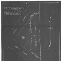
MAP.CC-010 - Map of "Tom Jenkins Ranch", Contra Costa County, CA.
Map of "Tom Jenkins Ranch". Court Case "Booth, James E. vs. Stow, J.M., et al., 1916"
Record Type: Archive
-
MAP.CC-011 - Map of Tom Jenkins Ranch
Map of Tom Jenkins Ranch. Court Case "Booth, James E. vs. Stow, J.M., et al., 1916"
Record Type: Archive
-
MAP.CC-012 - Richmond tunnel and highway plat
Richmond tunnel and highway plat showing Right-of-Way to be acquired. Map is located in Court Case "CoRichmond vs ATSF RR 1914."
Record Type: Archive
-
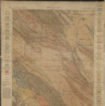
MAP.E-001 - Aerial Geology Concord Quadrangle, CALIFORNIA
1 map : col. ; 44 x 36 cm.
Record Type: Archive
-
MAP.E-002 - Plat of County road to be abandoned in the town of Danville
Blueprint. Plat of County road to be abandoned in the town of Danville. Supervisor District 2.
Record Type: Archive
-
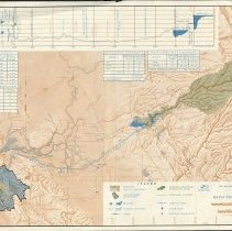
MAP.E-003 - EBMUD - Water Production System
EBMUD - Water Production System. California Coordinates Zone III
Record Type: Archive
-
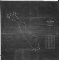
MAP.E-004-1 - Plat of the Rancho San Ramon
Plat of the Rancho San Ramon: finally confirmed to Horace W. Carparilier (sp).
Record Type: Archive