Archive Record
Images
Metadata
Object ID |
MAP.E-004-1 |
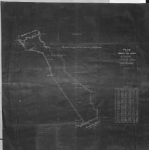
Title |
Plat of the Rancho San Ramon |
Description |
Plat of the Rancho San Ramon: finally confirmed to Horace W. Carparilier (sp). |
Collection Name |
Maps Collection |
Year |
1863 |
Map Area / Region |
Rancho San Ramon |
Publisher of Map |
U.S. SURVEYOR GENERAL |
Scale of Map |
[1:31,680]. 40 chs. to 1 |