Archives
Enter a word or phrase to perform a general search across all records in the Archives catalog. You can also browse records in the catalog without performing a search.
Search Tips
- Searches are not case sensitive.
- Searching for multiple words connects them with OR by default. Matching records can contain any of the words.
- Connect multiple words with AND if you only want to see records containing both words.
- Use quotation marks to search for a phrase.
- Place an asterisk (*) at the end of a word as a wildcard.
400 results found. Records searched: 400
-
MAP.E-022 - Map of Walnut Creek 1910 / By Carroll Walker
Hand drawn map. Shows building locations with owners, etc. Copy 2 is photocopy
Record Type: Archive
-
MAP.E-023-1 - AAA Map: Walnut Creek, Pleasant Hill, Lafayette, Alamo, Danville, Moraga, Rheem Valley
Central Contra Costa County Indexed. "8-66."
Record Type: Archive
-
MAP.E-023-2 - AAA Map: Walnut Creek, Pleasant Hill, Lafayette, Alamo, Danville, Moraga, Rheem Valley
Central Contra Costa County Indexed. "8-68."
Record Type: Archive
-
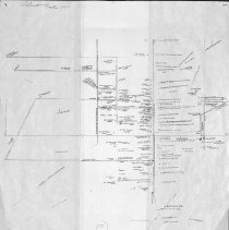
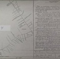
MAP.E-024 - Untitled map - notated as portions of Ignacio Valley Road
Includes "History: This is probably a portion of road from Walnut creek house to the "Deadfall" (sp?) References Road Record Book page 82 and 83. "Road C-27." Photocopy of ms. map.
Record Type: Archive
-
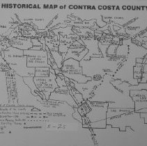
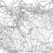
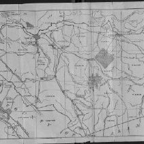
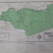
MAP.E-025 - Historical Map of Contra Costa County
Shows land grants, explorers' routes, ghost towns, abandoned railroads, mine sites and indian shell mounds. 2 copies. Copy 1 is a reduced Xerox of copy 2.
Record Type: Archive
-
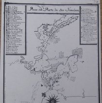
MAP.E-026 - Plano Del Puerto De San Francisco
San Francisco Bay Area 1 map : photocopy ; 24 x 20 cm.
Record Type: Archive
-
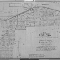
MAP.E-027 - Map of the Town of Crolona
Map of the Town of Crolona as surveyed for the California and Hawaiian Sugar Refining Company. Also showing the adjoining Towns of Crockett and Valona and Additions thereto. 1 map : photocopy ; 44 x 64 cm.
Record Type: Archive
-
MAP.E-028 - Map of Contra Costa County and Northern Alameda County
Contra Costa County and Northern Alameda County
Record Type: Archive
-
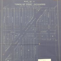
MAP.E-029 - Map No. 2 of the Town of Point Richmond
Map No. 2 of the Town of Point Richmond being plot No 51 of Rancho San Pablo
Record Type: Archive
-
MAP.E-030 - Partial plat of the Town of "Tormey"
Partial plat, Tormey, Contra Costa County
Record Type: Archive
-
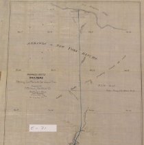
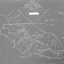
MAP.E-031 - Proposed route of a railroad from the Pittsburg Coal Mine to the San Joaquin River
Pittsburg area. Surveyed for the Pittsburg Railroad Co.
Record Type: Archive
-
-
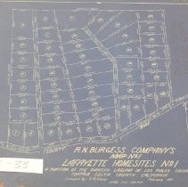
MAP.E-033 - R.N. Burgess Company's Map No.1, Lafayette Homesites No. 1
A portion of the Rancho Laguna De Los Palos Colorado. Surveyed by E.W. Glazier
Record Type: Archive
-
-
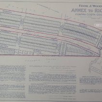
MAP.E-035 - Frank J. Woodward's Annex to Richmond
El Cerrito, Richmond, Contra Costa County
Record Type: Archive
-
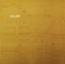
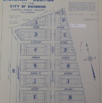
MAP.E-036 - Broadway addition to the City of Richmond
City of Richmond; 2 sheets. No. 1 is map; No. 2 is signature page and was not scanned
Record Type: Archive
-
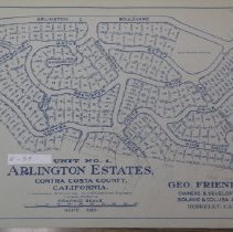
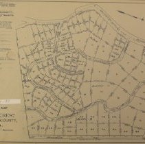
MAP.E-037 - Amended Official Map of "Arlington Estates"
Map of subdivision, Kensington. Compiled by R.R. Arnold, County Surveyor, Feb 1928
Record Type: Archive
-
MAP.E-038 - Map of a portion of Rancho El Sobrante
Land tracts, acreage. Rancho El Sobrante
Record Type: Archive
-
-
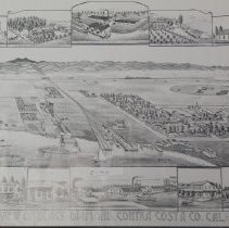
MAP.E-040 - View of Black Diamond, Contra Costa Co. CAL.
Perspective view not to scale. 2 copies
Record Type: Archive