Archives
Enter a word or phrase to perform a general search across all records in the Archives catalog. You can also browse records in the catalog without performing a search.
Search Tips
- Searches are not case sensitive.
- Searching for multiple words connects them with OR by default. Matching records can contain any of the words.
- Connect multiple words with AND if you only want to see records containing both words.
- Use quotation marks to search for a phrase.
- Place an asterisk (*) at the end of a word as a wildcard.
400 results found. Records searched: 400
-
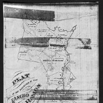
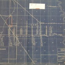
MAP.E-004-2 - Plat of the partition of the Rancho San Ramon
Plat of the partition of the Rancho San Ramon. Compiled from the field notes of William Isaac. 2 copies
Record Type: Archive
-
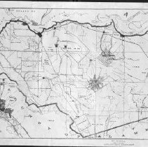
MAP.E-005 - Official Map of Contra Costa County, CALIFORNIA
Contra Costa County, CA
Record Type: Archive
-
MAP.E-006 - Lots in the Rancho Canada del Hambre Las Bolsas Rancho, CALIF EXHIBIT A
Dividing line between the Piper and Crockett portions of the southern part of the Rancho Canada del Hambre
Record Type: Archive
-
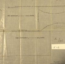
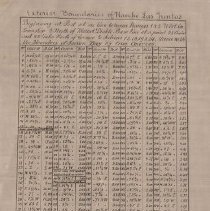
MAP.E-006-A - Exterior boundaries of Rancho Las Juntas
Exterior boundaries of Rancho Las Juntas, CALIF (Survey data) EXHIBIT B
Record Type: Archive
-
MAP.E-007 - East Contra Costa Irrigation Project
Map showing distribution of power requirements, Final Plan.
Record Type: Archive
-
MAP.E-008 - Special studies zones and flood hazard zones, Central Contra Costa County, CA
Base is typical Contra Costa County road map. "Special studies zones" are shown in yellow; "flood hazard zones" shown in blue; "special studies zones and flood hazard zones" shown in green.
Record Type: Archive

-
MAP.E-009 - Map of murder: Concord, CALIF.
Concord location near Bonafacio and Grant Streets
Record Type: Archive
-
MAP.E-010 - Putnam Realty Co's Reusch Ranch Subdivision
Handwriiten note on the back of map states that the subdivision was never developed. Property was on the Rancho Canada del Hambre.
Record Type: Archive
-
MAP.E-011 - Map of Gray's land sold to J[ohn] W. S[mith]
Lot, Cal. & Nev. Railroad at San Pablo and Bear Creeks. Watercolor; cloth
Record Type: Archive
![Map of Gray's land sold to J[ohn] W. S[mith]](https://s3.amazonaws.com/pastperfectonline/images/museum_1332/003/thumbs/mape011.jpg)
-
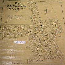
MAP.E-012 - Map of Pacheco CONTRA COSTA COUNTY CALIFORNIA 1869
Blocks & lots, town surveys 1858-63. 1 copy is annotated
Record Type: Archive
-
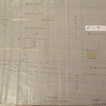
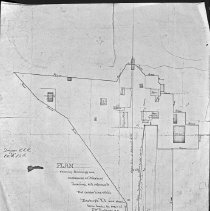
MAP.E-013 - PLAN showing buildings and enclosures at Pittsburg Landing
PLAN showing buildings and enclosures at Pittsburg Landing with reference to the center line of the PIttsburg R.R. and showing fence broken by order of J.W. Pinkerton on May 11, 1877. Diagram S.L.R., Ex. 'A', L.G.W.
Record Type: Archive
-
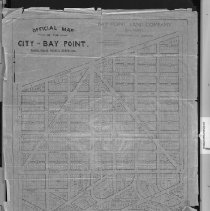
MAP.E-014-1 - Official map of the City of Bay Point, Contra Costa County, CA
Bay Point Land Company, Bay Point, Contra Costa Co., Cal Blocks & lots, etc. 2 copies ; both missing bottom 3" of map
Record Type: Archive
-
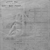
MAP.E-014-2 - Official map of the City of Bay Point, Contra Costa County, CA
Bay Point, Contra Costa Co. Shows blocks & lots, etc. This copy has annotations.
Record Type: Archive
-
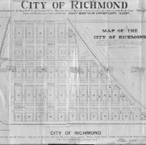
MAP.E-015 - Map of the City of Richmond
Map of that portion of the City of Richmond lying East of road 15 or 10th Street being a portion of lot No.54 of the final partition of the San Pablo Rancho. Lot nos.
Record Type: Archive
-
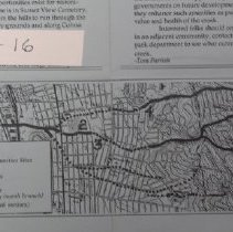
MAP.E-016 - Cerrito Creek : Future Restoration Opportunites Sites
Appears to be copied from a topo map. Contoured. From: Creeks Speak, v.1:3 (Jul.-Sep. 1990) p. 2-3, pub. by East Bay Citizens for Creek Restoration.
Record Type: Archive
-
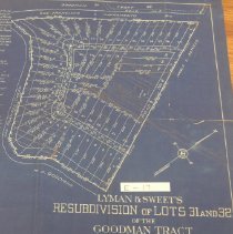
MAP.E-017 - Lyman & Sweet's Resubdivision of Lots 31 and 32 of the Goodman Tract
Incomplete. East of Las Trampas Creek & south of San Francisco-Sacramento Railway
Record Type: Archive
-
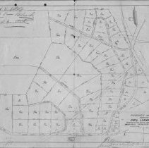
MAP.E-018 - R.N. Burgress Company's Map No. 1 Del Hambre
A portion of the Rancho Canada del Hambre. Annotated brown line print2 copies.
Record Type: Archive
-
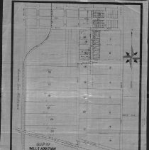
MAP.E-019 - Map of Wills Addition of the Town of Antioch
Also showing the partition of blocks 97-110. And lots 14 and 15 of the Wills Estate. Shows adjoining areas. Pen-and-ink & watercol. on cloth.
Record Type: Archive
-
MAP.E-020 - Map of the Rancho de Las Juntas, claimed by the heirs of W. Welch, surveyed by E. Hesse, Dept. Surv.
Negative photocopy of ms. found at the Bancroft Library (Land Case Map E-187). Map not dated but date here is for "Stip. for Claimant" filed 11/15/1861. See also OS-025 True and correct copy of the Rancho de las Juntas as surveyed by E. Hesse. Seal of the Surveyor of the U.S. Geological Survey affixed Oct. 28, 1861 Date of Reproduction not noted
Record Type: Archive
-
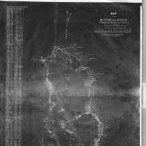
MAP.E-021 - Open Space Study
Contra Costa County to SFO, Pleasanton to San Rafael Undated
Record Type: Archive